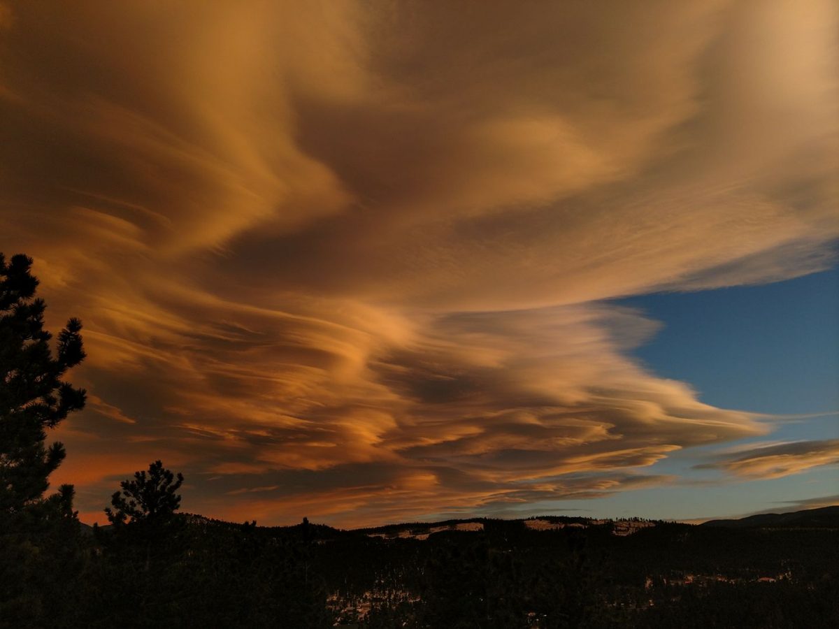
These last 5 months have absolutely flown by. Abby is packed and we leaving for Colorado.
Our time in California wasn’t all that we had hoped. We had hoped to travel more on the weekends, see more of the state. The Master Brewers Program was intense and weekends were spent studying. In hindsight, entire weekend trips would not have been wise, but day trips were feasible. We were within a couple hours drive of some amazing attractions (coast, Sierras, San Francisco, state parks). If we had given the situation more thought, we would have been able to enjoy the surrounding attractions much more.
What we will miss
View after sunset as the fog rolls in at Westport Union Landing State Beach.
The diversity and beauty of California. Mountains, rugged coast line, a fertile valley, redwood forests. There is a reason the meteorologists provide micro-climate forecasts in California, the character of these areas is extremely varied. We didn’t explore the state as much as we would have liked, but have so many reasons to keep returning.
The weather is truly spectacular (excluding the Central Valley’s heat in the summer) and rather gentle. When it rains, it doesn’t stay gray for 3 weeks. Rain falls, clouds clear out, sun is shining bright.
The produce – especially from the farm markets. It is amazing how fresh the produce is and how good fresh produce tastes. We have been purchasing avocados and we haven’t had a bad one yet. No careful monitoring of the avocado to make sure it is caught in that rare 15 minute window between inedible and rotten, no cursing when you realize you have again incorrectly estimated the state of our avocado. Besides the avocados, the strawberries! The apples! The broccoli! The cabbage! And so much more – all fresh, all flavorful. Farewell outstanding produce.
The people. We met some really awesome folks through the Master Brewers Program. It is rather bittersweet as everyone is scattering with the wind to different job and educational opportunities. Although, this does create a fantastic portfolio of breweries to visit.
Our landlady. Karen gave us a chance with our 3 dogs and 6 month lease. We appreciated the opportunity.
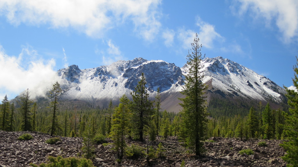
Fresh June snow fall on Mount Lassen.
What we won’t miss
The heat. Summer is just getting started in the Central Valley and it hasn’t even truly gotten hot yet (only up to 105 Fahrenheit so far). But far too hot for us.
So, fare thee well California. We wish a very rainy winter to help alleviate the drought and build a fantastic snow pack. Our plan is come back for vacation.
We did not do this drive in one day. It actually took us two. We stopped and stayed at Mad River Rapids RV Park (clean, nice bathrooms, laundry, just a little too developed for our preferences) in McKinleyville, CA the night of June 21st. Cell reception was critical for the morning of the 22nd because Jess had a phone interview for a job. The saving grace of this stop was Six Rivers Brewery, just 5 minutes away from our campground. We enjoyed their beers.
Just south of Eureka, we debated on taking Mattole road along the lost coast. It is a beautiful drive; we have done it before in a rental car and motorcycle. However, it is twisty with lots of up and downs. We decided not to abuse Abby that badly a few weeks before our move to Colorado. We decided to enjoy the drive along Avenue of the Giants for the scenic portion of our drive.
History: Westport and Union Landing were towns supported by the lumber industry. A complex wharf and chute system was used to load the schooners anchored beyond the dangerous rocks with lumber, tanbark, shingles, wool, oats and railroad ties from the bluffs. The town struggled through boom and bust cycles, and the Great Depression diminished Westport further. The town survives today, unlike other lumber towns along the coast.
Campgrounds:
With our late start on the 22nd, we started to look for camping in Humboldt Redwoods State Park. We were shut out the previous night at Prairie Creek Redwoods State Park; this park is very popular and after hiking to Patrick’s Point, it was clear why. Make a reservation, it will be worth it. We were cautiously optimistic about finding a spot in Humboldt Redwoods. The Burlington campground, where we (minus Alex) camped in 2010 was full, and the park staff recommended Hidden Springs. This was a fantastic recommendation. We selected site 9, which was level and had a nice area for Alex and the dogs. There was some road noise, but the number of cars traveling on the road decreased significantly after dusk.
We got off to an early start on Thursday and as we drove by Westport Union Landing State Beach we saw campsites set up. We stopped to investigate and discovered that this is a first come, first serve campground. We snagged a spot for two nights. Initially, there looked to be a limited number of spots, but there are three camping areas.
Activities:
View from Patrick’s Point towards Wedding Rock.
Various hiking trails are available at Humboldt Redwoods State Park and Prairie Creek. Prairie Creek will have ocean view trails. At the Eel River swimming hole in Humboldt Redwoods State Park, Alex took great joy in throwing rocks into the river. It is an activity he enjoys.
Alex waiting for a wave to come in so he can throw a rock into the ocean.Penny and Chewie running on the beach.
Westport Union Landing State Beach has, well, the beach. This can be walked to and at low tide you can find sand crabs, crabs, giant anemones, and mussels. Alex took a little bit to warm up to the beach and preferred to walk on the harder sand exposed during low tide. Once he discovered this surface, he was eager to run up and down the beach. The dogs were excited to frolic in the surf.
Fort Bragg is about 15 miles down the road. Fort Bragg is the home of North Coast Brewing Company and their very tasty beers. There is a tourist train, called the Skunk Train, that takes riders on a forty mile tour through redwoods and mountain meadows. We missed an opportunity to take Alex on a train ride that he would have loved. There is also Glass Beach, where beauty has resulted from a former city dump.
Overall: Fantastic camping spot. Need to be quick to grab a site. The proximity to Fort Bragg provides extra activities. We could have spend our entire trip camped out on the bluffs.
We got off to a relatively early start because the day’s activities included grocery shopping and laundry! We were westward bound on CA-96W until Happy Camp. We stopped at the Frontier Saloon and Cafe for second breakfast; Dave finally staged his uprising against granola and yogurt and insisted we stop. Portions were generous, food was good. Bacon was amazing – thick cut, not overly salted. Stop in if you are in town.
Our route took us through a remote area; the steep mountain slopes are not conducive to building. The road was twisty and when we crossed into Oregon, Abby earned another state badge. We debated on detouring to the Oregon Caves National Monument and Preserve, but it was 45 minutes out of our way and we needed clean undies. We turned south to Crescent City. We arrived and wanted to stop and Port O’Pints, but they didn’t open until 2. And there was no food as far as we could tell. Pre-made salad from Safeway for the lunch win!
Dave standing by the stump of a redwood.
History: Redwood logging began in 1851, as the gold rush waned. Technological advances made it easier and faster to harvest the large trees. In 1920, key groves were preserved by the State of California. In 1968, Congress created Redwood National Park, protecting the world’s tallest trees and Redwood Creek’s salmon fishery.
Redwood log next to campsite 40.
Coast redwoods have been recorded at 370 feet, almost 70 feet taller than the giant sequoia. There are no known killing diseases and are resistant to insects, believed to be the result of high tannin concentrations, which also provides the red hue to the wood. Fog, created by the hot air of the central valley pulling moisture laden ocean air towards the interior of CA, is key to the survival of the coastal redwood.
Stand of young redwoods.
Redwood National and State Parks are a cooperative management effort between the National Park Service and the California Department of Parks and Recreation. Redwood National Park, Jedediah Smith Redwoods State Park, Del Norte Coast Redwoods State Park, and Prairie Creek Redwoods State Park are part of the cooperative effort and form a World Heritage Site and International Biosphere Reserve.
Campground: We stayed at Mill Creek campground in Del Norte Coast Redwoods State Park. We were lucky to get a walk-up site, number 41. Sites 40 through 42 are spaced the closest and receive the most sunlight. The sites are level and have easy access to Mill Creek. Sites 39 and 55 are prime sites, spacious and well separated from neighboring campsites. Overall, most sites in the camp well spaced. There are some tent only sites that are extremely secluded – you hike to the tent platform through a tunnel in the foliage.
Alex enjoying the rocks in Mill Creek.
Activities: Fishing in the park tributaries of the Smith River for cutthroat trout and hatchery steelhead is permitted. Mill Creek is closed to fishing part of the year. A license is required.
Alex enjoying the hike along Trestle Trail on his pack mule.
There are a variety of trails for hiking in the park. The Trestle Trail Loop circumvents sites 1 – 74. Off of this trail, one can access the Adler Basin, Saddler Skyline, and Hobbs Wall (via Saddler Skyline) trails. The California Coastal Trail, which is 1200 miles long, runs through the park. Also in the park is the Damnation Trail, which was used by the Tolowa Indians to reach the ocean to gather shellfish and seaweed. This trail drops 1,000 feet over two miles through old-growth redwoods and Sitka spruce. We thought about attempting this hike, but wisely did the math in advance. The average grade on the trail is 10%. We opted for the Trestle Loop Trail instead. This trail was a combination of a relatively flat and wide path (good for Alex to walk a bit) and some narrow, steep hillside hiking (good time to contain Alex in the pack).
Overall: This was a fantastic campground and would be a fantastic place to set up home base for a couple of weeks and explore the coast. There are endless day trip possibilities. Also, the proximity to Crescent City means it is easy to restock food and clean clothes.
Route for Lassen Volcanic National Park to Sarah Totten Campground.
Route: CA-44W, I-5N, CA-96W
We got off to a late start. Our route decision was strategic because it would take us through Redding around lunch time and we had a brewery recommendation. Alas, the recommended brewery did not have food, so we stopped at Woody’s Brewing Company. We posted about our experience here, but the quick summary is good food and good beer. Worth a visit. Stomachs filled, we continued our journey.
History: We have been commenting that the farther we drive north, the less the California feels like, well, California. The area’s residents agree based on the number of ‘State of Jefferson‘ flags we observed. The proposed state spans contiguous, primarily rural, counties of southern Oregon and Northern California. There is a separate independence movement called Cascadia.
In the early 20th century the State of Jefferson felt that it was being left behind as the rest of California thrived. In 1941 local leaders worked to establish the State of Jefferson. However, with the bombing of Pearl Harbor, the secession plans were abandoned. The movement still continues today as a criticism to the growing role the federal and state government and how decisions made by these governing bodies negatively impact the region. Check out the segment on the State of Jefferson on the show How the States Got Their Shapes.
We also saw numerous ‘No Monument‘ signs. Curious, we Googled the issue. The Siskiyou Crest runs east-west and links the Siskiyou Mountains to the Cascades. The area has high biological diversity, believed to have resulted from the fact it was unglaciated during the last Ice Age and served as a refuge for plants and animals. The creation of the monument, out of land already managed by the U.S. Forest Service, aims to protect and revive the land. The classification as a monument would restrict grazing, logging, and mining inside the boundaries. Those in opposition fear worsening economic stagnation and that private property would be taken away from citizens. Supporters believe that the new designation would bring tourism and outdoor recreation dollars. The monument is supported by the Klamath-Siskiyou Wildlands Center and opposed by the American Land Rights Association.
Abby in site 8 at the Sarah Totten Campground.
Campground: The Sarah Totten Campground in the Klamath National Forest is a small campground along the Klamath River and has two group sites and nine individual sites. The campground has an upstream and downstream loop, with river access at the upstream loop. We camped in site 8 in the upstream loop which is next to the river access. No one was using the river access, but this campsite would be less than ideal if there was a high demand to access the river.
Alex looking for rocks to toss into the river.
Activities: If we had a tow vehicle and kayaks, this campground is ideal. Drive the tow vehicle to the put out point, bring the RV and kayaks back to the campground. A recipe for an enjoyable time on the river. There were also multiple trail heads accessible from CA-96W, but we did not go hiking. There is a nice selection of rocks for throwing in the river.
Overall: A very isolated campground. Use does not seem to be heavy. A gorgeous area to camp. Site signage could be improved.
The route traveled to Lassen Volcanic National Park.
Route: CA-89N
As we drove, Dave commented that the landscape was feeling less like California (grey, rocky mountains) and more like the Pacific Northwest (thick pine forests, lots of logging trucks). A quick consult with the map showed that Lassen National Forest straddles the Sierra and Cascade ranges, which are quintessential California and Pacific Northwest, respectively. The drive was picturesque, with twisty roads following creeks and cutting along the mountain. All the plants were freshly green, having recently shaken off winter’s chill.
Abby parked at the Lassen Peak trail head.
We were expecting to see much more snow during the drive, since CA-89, the Lassen Volcanic National Park through road, had only recently been cleared of snow and opened. However, we only saw occasional patches of snow. Then we started to climb as we entered the park and the odds were in our favor (and Penny’s) significant snow. It did not take long after entering the park before there was snow, and significant quantities. The drive was a bit harrowing with the thick fog, but the positive side was we could not see the steep drop offs along the road. If you feel that the government is over protecting you, drive the road through Lassen. There isn’t much government protection standing between you and the drop off.
300 ton rock landed 3 miles from Mount Lassen after the 1915 eruption.
History: Designated a National park on August 9, 1916, in part due to the continuing volcanic activity after the 1915 eruption. President Theodore Roosevelt initially protected the area with the formation of Cinder Cone National Monument and Lassen Peak National Monument in 1905.
Native Americans inhabited the area and believed that Lassen would one day blow itself apart. Lassen Peak was used as a landmark for immigrants on their way to the fertile Sacramento Valley.
Campground: We stayed at the Manzanita Lake campground, in the Northwest corner of the park; this was the only campground open. The other campgrounds were still being cleared of winter related damage. This campground has four loops. Sites can be reserved on loops A and C, loops B and D are first come, first served. Loop D is for tent camping only. There are multiple trail heads in or close to the campground (Manzanita Creek, Crags Lake, Manzanita Lake, Lily Pond Nature Trail, Reflection Lake, Nobles Emigrant). We were in site C44, which was spacious with and felt secluded. Other prime sites in the C loop include C22, C24, C25, and C26. There is no cell service.
Alex sleeping during the hike to Crags Lake.Heading over the crest to Crags Lake.View of Chaos Crags from Crags Lake.
Activities: Kayaks can be rented from the camp store for use on Manzanita Lake. We decided to hike the Chaos Crags trail. The sign at the trail head, which was a solid 0.5 miles away from our campsite, indicated a 2 mile walk with approximately 825 feet of elevation increase. Simple math, done at leisure after the hike, determined that the average grade of the trail was 8%. Math, it rocks. There were sections that were rather flat, and sections that were very steep. The 4 mile round trip took us about 3.5 hours. This time includes the 30 minutes we spent at Crags Lake watching Alex throw rocks into the water and laugh at the ‘bloops’. The hike offered amazing views and took us throw an area that had been affected by fire. The hike was sunnier than expected due to reduced tree cover. And there is cell service! We definitely were sore after this hike.
Snow field along a creek. Penny is clearly happy.
Skiing and snowboarding are also options for activities! In June! Our first night camping, it rained at the campground, but higher elevations received approximately six inches of snow. The through road was closed again to allow for plowing.
Ski and snowboarders at the Lassen trail head.
The Kohm Yah-mah-nee Visitor Center has great interactive displays. There is a description of the different types of volcanoes (cinder cone, composite, plug flow) and an interactive map that will light up the type examples with in the park with the push of a button (Alex loved this). Another interactive exhibit had a tunnel that was perfect for a toddler to run through; a light lit up as Alex ran through the tunnel. This was also a great source of joy. Two gift shops, an area with children’s toys, a cafe, and theater round out the offerings at the visitor center.
Overall: This is a beautiful park with hiking options that we did not even scratch the surface of in regards to activities and hikes. Note that if you are interested in the Lave Tube caves, which are located in Lassen National Forest, about 45 minutes north on CA-44/CA-89. As our usual, we wish we were spending more time here.
Google estimated travel time was approximately 3 hours if we used I-80E for the majority of the trip. On the advice from a friend, we overruled Google Maps and took CA-49N, which would add an estimated 30 minutes to the trip. In Abby, the extra time was closer to an hour. Include the road construction, it was an additional 90 minutes.
CA-49N is a twisty, scenic drive through Tahoe and Plumas National Forests. The road follows various branches of the Yuba River at different points. The river looks to be a kayaker’s and fisherman’s paradise with boulders, fast flowing sections, and large pools. There are multiple opportunities to camp in Sierra County at National Forest campgrounds adjacent to CA-49N. We also saw a number of signs indicating boat launches down lake access roads.
Yes, the route we took came close to forming a circle at the end.
Abby in campsite 36 at Plumas Eureka State Park.
History: The Plumas Eureka State Park region was originally inhabited by the Northern Maidu, who lived along valley edges and hunted in the mountains during the warm seasons. They were known for their coiled and twined baskets and intricate bead-work.
In 1851, the isolation of the Maidu ended when gold was discovered on an exposed quartz ledge of Eureka Peak. The influx of European settlers brought disease, destroyed native food and plant resources, and inflicted violence that was catastrophic to the Maidu population.
Jamison City and Johnsville were established for the miners. Smaller mining companies closed as surface deposits diminished. A British company purchased and consolidated the mines in 1872. The mines operated profitable until 1890 and were sold in 1904. Operations tapered off until they were ended during World War II by the War Production Board Limitation Order. The mines’ 65 miles of tunnels generated more than $8 million in gold, which was processed by the Mohawk Stamp Mill.
To entertain themselves, miners held snowshoe and ski races. In the ski races, competitors could reach speeds of more than 80 miles per hour. It is believed that the mine tramways may have served as the world’s first ski lifts.
Campground: We weren’t sure what to expect with the Plumas Eureka campground. Experience with CA state parks is approximately 66% positive (Morro Bay, New Brighton State Beach, Half Moon Bay) and we were hoping that after this stay, 3 out of 4 parks would have exceeded expectations. We weren’t disappointed.
The park rangers are VERY serious about protecting bears from habituation to humans. You must read a statement upon check in regarding proper storage of food and trash at your site and the dangers to you and the bear if you do not follow the regulations; there is a $1000 fine if you are found to be in violation of the rules. Your signature on the registration receipt is required to acknowledge the information.
The campground is approximately a mile down the road from the mining museum, located at the base of Mount Eureka, that has the registration window. There is a mix of walk-in only and RV/trailer sites. all sites have a picnic table, fire pit, metal food storage box, and a large level area for tent set up. Despite the scale on the map, all sites are spacious and wooded with various types of trees (white fir, Douglas fir, ponderosa, sugar, Jeffrey, lodge-pole, incense cedar). There are even some giant sequoias and a creek running through the campground. Our spot number was 36, which was a little uneven, but was fixed with blocks under the front tires. Sites 9 – 14, and 19 – 20 are secluded and within easy walking distance to the showers.
The shower facilities were clean, and as of June 2016, free. We did not try them out. California was experiencing unseasonable cold weather and we saw snow flurries our first night. We’re not walking around wet, in the cold, while Abby had a functional shower. The toilet facilities have flush toilets, but no hot water.
Activities: There is a trail from the campground to the museum. The museum is located in the historic miners’ bunkhouse and has natural history exhibits, archaeological finds, mining artifacts, a working scale model of the stamp mill, and hands on exhibits for kids. You can even pan for gold. Some buildings are open in the mining complex, but check with the museum to confirm days and times.
The campground also provides access to the Talking Forest Nature Trail and Grass and Smith Lakes Trail. These trails to exit the state park and enter national forest land. Within the park, there are also trail heads to Eureka Peak, Madora Lake, and others into national forest land.
Fishing along Jamison Creek in the park is not always rewarding, but there are other streams and lakes in the area that offer better odds.
Check out The Brewing Lair. It is about a 10 minute drive from the campground at Plumas Eureka State Park. We loved their phenomenal setting and enjoyed their beer. Well done.
Overall: We enjoyed this park. We didn’t hike as much as we would have liked; we are always trying to hit a moving target as Alex abilities and nap schedule change as he grows. A positive experience.
Sylvan Lake Campground at Custer State Park, SD: Sites were well spaced, secluded, grounds were well taken care of. Site was level. Our campsite was tucked away among trees. The campground was not on the lake, but was a quick hike to the lake and there was access several trail heads. Scenery was gorgeous.
This campground has sites that are a stone’s throw away from the rim of the gorge. Visitors center is a short hike away. Some hiking trails along the gorge rim. Gorgeous scenery. Sites are well spaced and level. We wouldn’t camp here again until Alex is older and listens better. Jess would become instantaneously grey making sure Alex didn’t fall into the gorge. Or he will need one of those child leashes.
View from the Red Canyon Campground in Flaming Gorge National Recreation Area.
Mueller State Park, CO: This campground had nicely spaced, wooded sites. Some sites had a view of Pike’s Peak, but these go quickly on the reservations page. Great laundry facility and playgroud for Alex. Alex’s wagon came into play as our laundry mobile when walking up the hill to the laundromat. Park is well cared for and the staff is friendly. Group sites also available.
View of Pike’s Peak, obscured by cloud cover.
Least Favorites
Mormon Island State Recreation Area, NE: Campground is next to a lake, on an island, in the middle of the Platte River. The lake is part of Nebraska’s Chain of Lakes; these lakes are water filled excavation pits from I-80’s construction and converted to recreation areas.. We stayed here because it was easy access to I-80, had full hook-ups (needed to run the A/C due to the heat and humidity), and it was approximately the target distance we wanted to drive in a day upon leaving Colorado. The lake’s aroma left a bit to be desired. Campground served its purpose, but it was cruel switch from the Rockies.
Starved Rock State Park, IL: The park website looks amazing! Don’t be fooled, the campground is definitely not amazing. If the campground is in the park, it is on the border. You do drive past the beautiful area to the campground, which is mosquito infested to the point you can’t be outside. We would have rather stayed in a commercial campground.
Biggest Pleasant Surprise
View from the bluff at Great River Bluffs State Park, MN.
Great River Bluffs State Park, MN: The geological features of this park are the result of minimal glacial drift from any of the four major glaciers. Sites were well spaced and wooded. Some are not level, so check the reservation site, it should provide information. Nice hiking trails with views of the Mississippi River Valley. And there were little chipmunks for Penny to watch from Abby’s window.
Penny watching chipmunks at Great River Bluffs State Park, MN.
Biggest Disappointment
Yellowstone, WY: It was Fourth of July weekend. There were hordes of people and we were lucky to get a spot. Campsites were crowded. People were oblivious to etiquette. The bathrooms were not clean. Dave said he would rather take one of the poop bags for the dogs out to the woods rather than use the bathroom. Jess was too scared to see the horrors of the women’s bathroom. There will be a separate Yellowstone post to discuss why this was our least favorite park of the entire trip. I’m sure Yellowstone is much nicer when it isn’t the peak travel season.
We started our first long RV adventure on June 27, 2015. We had made the decision just three weeks prior to move to California so Jess could enroll in the UC Davis Extension Master Brewers Program; we knew that when we returned we would have to kick things into high gear to prepare the house for sale (we had our floors refinished while we were gone). Looking back, it is hard to believe we got it all done. And it is still rather surreal that a year later we are packing up our California rental to move to Colorado.
Since it has been so long since our trip, the format for posts will be different from our California move. This summary post will be followed by posts focusing on our favorite/least favorite campgrounds, side trips made along the way, and anything else that may require a stand alone post. These stand alone posts will likely be due excessive length as a result of our poor self-editing skills. Some of our notes (including total gallons of diesel and mileage) have been misplaced in a cross-country move.
2015 Summer Trip
The trip was approximately 5200 miles, including side trips. We used about 345 gallons of diesel, averaging right around 15 miles per gallon.
We started our trip on June 27, 2015 and were back July 16, 2015. Just shy of 3 full weeks and resulting in an average of 273 miles traveled per day.
Family selfie just before leaving the driveway.
The trip started out on a rainy, mechanical break down note with Abby’s turbo resonator failing, but after our first day hiccup, it was smooth sailing. We had a great time visiting family and friends along our route. And they were always very kind in giving us a place to park, do laundry, and shower in a full size bathroom!
The whirlwind trip took us to four national parks, a national monument, a national recreation area, two national forests, and seven state parks. We definitely erred in wedged too many sights into our trip schedule; we learned from our errors on this trip and corrected them for future trips.
Located in Blairsden, CA, the The Brewing Lair has a superior setting (What? We should have taken pictures? We didn’t, check out the website). Tucked away in the Sierra’s along the Pacific Crest Trail, the brewery has a 9 hole disc golf course (15 acres), a slack line, and 3 BBQ grills for cooking (first come, first serve). They have several levels of outdoor seating with Adirondack chairs and picnic tables. They even have a nice selection of toys for kids (Blaze, hula hoops, Lightning McQueen, dinosaurs). The brewery is approximately a 10 minute drive from Plumas-Eureka State Park.
The Brewing Lair Sampler.
We tried the sampler that consisted of the Blair Belgian Blonde Ale, Ambush IPA, Take a Hike India Red Ale, Black IPA, and Solo Session with Mosaic hops. These, with the exception of the Blair, were hop forward. All the beers were well done and we enjoyed them, despite them being outside of what we usually order. We went back for pints of the Blair and the Black IPA. This is brewery is well worth the trip.
Woody’s Brewing Company
Fully pour of the Apricot Wheat at Woody’s and their beer selection.
Located in Redding, CA, Woody’s Brewing Company was a great spot for lunch and beer. We again opened with the sampler and there wasn’t a beer we didn’t like. Full pours were ordered of the Apricot Wheat (hint of apricot, not overly sweet) and the Pray for Powder Porter (just very nicely done). The food was also top notch – the jalapeno burger has flattened, deep-fried jalapenos on it. Very tasty. If you are in the area, it is worth the stop.
Lost Coast Brewery
Located in Eureka, CA, we first stopped at the Lost Coast Brewery in 2010 and again in 2012. Since our last visit, Eureka seems to be a bit more down on its luck. The brewery remains rather unchanged from our memory. We settled in and grabbed a sampler. We really do like the sampler as an easy way to taste all the beers. We found the 8 Ball Stout to be one of the better beers, but, were underwhelmed in general. The Famous Hot Brown was meh, and fell short regarding the description. The 8 Ball Stout Beef stew was delicious, although light on the meat. We might stop here again, but it won’t go out of our way to do so.
Six Rivers Brewery
The sampler at Six Rivers.
Located in Mckinleyville, Six Rivers Brewery was the highlight to our day. Forced into a commercial campground for the night due to the need for cell reception for Jess’ phone interview the next day, we needed some good beer to off set the less than picturesque accommodations. Six Rivers came highly recommended by a friend and former classmate of Jess’. The sampler was ordered again, and much drinking ensued. The Chili Pepper Spicy Ale was overwhelming, the tip to mix it 50/50 with Strawberry Wheat came too late to help us. The summer sour was well done, with a hint of acid, but not excessive. The IPAs were all nicely done.
The Buffalo Chicken sandwich had nice heat to it and the burger wasn’t one to drive for, but was edible. Had a really nice Kid’s Platter with a wide selection for those little grazers.
North Coast Brewing Company
The sampler at North Coast Brewing Company.
North Coast Brewing Company, in Fort Bragg was the last stop of our trip. Our final sampler of delicious beers. No truly bad beer in the bunch. The Red Seal beer engine sampler had the aroma of diacetyl (buttery), but the non-beer engine Red Seal was as expected. Possible the beer engine needed new lines or the beer was not moving quickly. Old 38 Stout, Brother Thelonius, Old Stock Ale, Pranqster, and Blue Star were some of our favorites.
The food was also very good. The Carolina BBQ kurubota pork was juicy, tender, and had that expected vinegar tang. The rosemary chicken was nicely cooked and was served with a delicious sauce. We sat at the bar a number of years ago, and to the best of our recollection, the tap room has changed since then (time does march on!). The tap room seemed to have a more upscale feel to it, but 6 or so years will cloud the memory.
It is a good thing we don’t live near Fort Bragg – our wallets would be quite thin from all our North Coast visits.
Summary
We enjoyed revisiting breweries and trying out new places. It is definitely a different experience with Alex in tow, but with a little help from the electronic baby sitter (DVD player), we were able to enjoy some beer.
Hands down, the Brewing Lair had the best setting. A must visit if you are in the area; also great for Alex (an other kids) because he got to play outside and there were toys.
For beer, North Coast did not disappoint. Woody’s was a nice surprise, we stopped because we needed lunch and they served food. We are very glad we did, it was quite enjoyable. The Brewing Lair beer styles were outside of what we normally seek out, but well done.
Sadly, this is a non-Abby post because we decided to take a day trip to Muir Woods National Monument. We have been around Muir Woods on previous trips, but never managed to visit. The land that became Muir Woods was purchased by William Kent, a local businessman, and his wife Elizabeth Thatcher Kent in 1905. This land included one of the last uncut stands of redwoods and was donated to the federal government. In 1908, President Theodore Roosevelt proclaimed the area a national monument under the power of the 1906 Antiquities Act, and was named to honor John Muir, conservationist. Flora includes coast redwoods; shade-loving undergrowth, such as sword ferns, mosses, redwood sorrell; and wildflowers – trillium, clintonia, and redwood violet. Fauna include spotted owls, bats, raccoons, deer, birds (warblers, thrushes, Pacific wrens, Stellar’s jays), banana slugs, Sonoma chipmunks, and western gray squirrels.
Our parking spot in Muir Woods. Normally, we wouldn’t park next to this guy, but spots were at a premium. Car on the other side didn’t actual encroach into our space, but was parked on the line. Jess let Dave and Alex out of the car, parked, and then climbed out the rear hatch.
Our initial plan was to drive down after lunch so the trip would coincide with Alex’s nap. After reading the National Park Service’s tips for a visit, we decided to get on the road around 8. We pulled in at 10:15 and were extremely fortunate to get a parking space in the overflow lot at the Visitor’s Center. And that spot was wedged between the second place finishers in the asshole parking competition (we had to pull the mirrors in on the car). The first place finishers were parked so badly that you couldn’t squeeze into the spot between them. When we left at 12:30, it was absolute chaos in the parking lot and the overflow lot was also full. So, last minute plan changes work out.
With Alex in tow, we opted to stay on the trails close to the visitors center – mostly paved or board walk and smooth. Great surface for a little boy to walk/run/jump and burn off some serious energy. Jess and Alex abandoned Dave at the gift shop and took off across Bridge 1. Without cell service, Jess had to corral a very unhappy boy, find Dave, and then the journey could begin again. Alex ran along the trail until we reached the Hillside trail head and Alex chose to head up this path.
Hiking on the Hillside Trail in Muir Woods.Alex on the path in Muir Woods.
The beginning of the Hillside Trail after the Bohemian Grove was quite reasonable – rather wide and smooth, but with a rather steep drop off. Soon it became very narrow and rough, completely inappropriate to have an energetic two year-old free roaming. We packed Alex up in the Osprey child carrier and carried him until we crossed Bridge 4 and returned to the paved path. Along the Hillside Trail we encountered an 8 inch banana slug and Alex had fun cawing at a bird high up in the trees. Alex enjoyed touching a pair of trees we had to walk between on the trail and cried when we kept on walking. He is a curious kid and doesn’t like to leave his interests before he is done checking everything out.
Alex inspecting the signs in Muir Woods.
Alex also really liked the signs instructing us to stay on the board walk. He inspected them closely trying to figure out how they were constructed and picked out the letter ‘A’ and ‘T’ in each sign. Whenever he saw the ‘T’ he said ‘choo choo’ for train.
Alex checking out a hollow in a tree on the marked trail.
Overall, we had a great time. The paths near the visitors center are packed, and if we had some more time and were more familiar with the trails that would be better for Alex, we would have ventured farther away from the Visitor’s Center. It took us about 2 hours to walk a 1.5 mile loop, which can be completed more quickly if a toddler isn’t setting your pace. Getting there early is key for securing a parking spot.


 We did not do this drive in one day. It actually took us two. We stopped and stayed at


 Westport Union Landing State Beach has, well, the beach. This can be walked to and at low tide you can find sand crabs, crabs, giant anemones, and mussels. Alex took a little bit to warm up to the beach and preferred to walk on the harder sand exposed during low tide. Once he discovered this surface, he was eager to run up and down the beach. The dogs were excited to frolic in the surf.

 Route: CA-96W, Indian Creek Road, US-199S


 We tried the sampler that consisted of the Blair Belgian Blonde Ale, Ambush IPA, Take a Hike India Red Ale, Black IPA, and Solo Session with Mosaic hops. These, with the exception of the Blair, were hop forward. All the beers were well done and we enjoyed them, despite them being outside of what we usually order. We went back for pints of the Blair and the Black IPA. This is brewery is well worth the trip.


